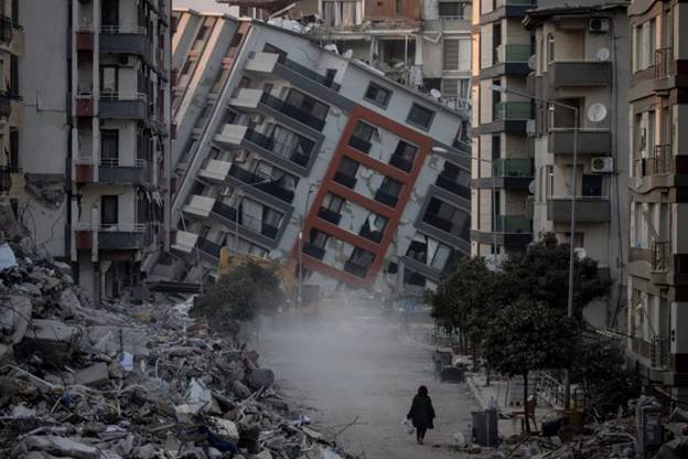
A partially collapsed building in Gaziantep, Turkey, after a 7.8 magnitude earthquake rocked the city. The Cascadia Subduction Zone can produce even larger, more dangerous quakes - Chris McGrath/Getty Images
Scientists Now Know Where the Most Dangerous Part of The US Earthquake Zone Is
By Ellyn Lapointe
Hidden off the US Western shore, beneath the Pacific Ocean, is the Cascadia Subduction Zone . This fault is capable of generating earthquakes larger than magnitude 8 that can be felt hundreds of miles away, and a recent study has pinpointed the most dangerous segment along its 700-mile-long stretch.
The results will help scientists assess earthquake and tsunami risk for this region, including one particularly vulnerable state: Washington.
"This has been a subduction zone that's been under-studied with the kinds of tools that we have available now," geophysicist Suzanne Carbotte, a Bruce Heezen Lamont research professor at Columbia University, told Business Insider.
Armed with state-of-the-art technology that can probe deep beneath the ocean floor and create images, Carbotte and her team produced the first comprehensive survey of Cascadia's complex, below-ground composition. They published their work in the peer-reviewed journal Science Advances.
The researchers discovered that Cascadia is broken up into at least four segments, which had been suggested by previous studies but never confirmed, Carbotte said.
The picture "before our study was a smooth surface with no obvious relationship to this segmentation," Carbotte said. "But that smooth surface was based on very, very sparse data. And in places, no data."
This new picture provides a much more accurate view of Cascadia's complexity, and of the risk it poses to the US West Coast .
How the Cascadia Subduction Zone causes earthquakes

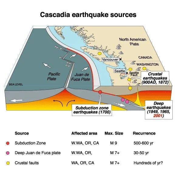
In the Cascadia Subduction Zone, the Juan de Fuca plate is slowly subducting under North America. As these two tectonic plates move against each other, it could trigger a giant earthquake - USGS/Wikimedia commons
Cascadia is essentially the border between two tectonic plates: the massive North American continent, and the smaller Juan de Fuca plate.
The Juan de Fuca plate is gradually sliding (or subducting) eastward beneath the North American plate , which creates a megathrust fault: a place where tectonic plates move against each other in a dangerous way.
The stress that's driving the Juan de Fuca plate under North America is continuous, Carbotte explained, but the plate's movement is not. Sometimes, it gets stuck.
When locking up like this, the plates can only absorb stress for so long before they finally rupture, triggering an earthquake , she said.
This is what scientists think happened about 300 years ago when the zone ruptured offshore and the resulting earthquake formed a massive tsunami that slammed into the coast of Japan.
While Cascadia hasn't produced a great earthquake since 1700, it's only a matter of time.
Scientists can't predict earthquakes but they can get a better idea of risk by understanding the fault's complex structure deep below ground.
Carbotte and her team have moved the needle significantly on that front.
Zeroing in on risk
Carbotte and her team found lots of variability in the megathrust's structure, which likely means that the hazard varies at different locations along the fault, said Janet Watt, research geophysicist at US Geological Survey Santa Cruz who was not involved in the study.
"It's not a one-size-fits-all answer, but it gives us an appreciation for that complexity," Watt, speaking about Carbotte's results, told BI.
Additionally, understanding that Cascadia is broken up into segments is key to assessing earthquake hazard, Watt said. That's because this segmentation means that the megathrust could rupture in pieces, rather than all at once. This could impact the size of future earthquakes because shorter ruptures trigger smaller quakes.
What's more, the unique characteristics of each of these segments means each one poses a different level of risk . Another key finding from Carbotte's study is that one of Cascadia's segments is probably more likely to produce a great earthquake than the others.
This particularly dangerous segment essentially spans the coast of Washington , running from the northern Oregon border to southern British Columbia. It's flatter and smoother than the other segments, meaning it could trigger the largest earthquakes, Carbotte told BI in an email.
Plus, this segment likely extends further into the US than the others, which is bad news for the state of Washington . If this segment ruptured, Washington's coastal communities could face the most extreme shaking, although the quake would extend far beyond state borders, Carbotte wrote.
Knowing that could help this state prepare for the worst-case scenario . "I think this is an example of a study that will lead to action in the future in terms of building resiliency along the coastline. And it'll be exciting to see where the science takes us," Watt said.
Carbotte's research emerges in the context of many other studies that are currently working to bring our picture of Cascadia into sharper focus.
"This is one particular study of a larger community effort that is going on to [understand] the system, and then communicate what that means to communities on the coastline and inland, and how we can actually turn science into action ," Watt said. - Business Insider

